The Postgraduate Certificate and Diploma
For more information, please consult the
Study Guide
1) What will I learn?
The Postgraduate Diploma Course aims to provide students with an understanding
of the technical, geographical and organizational aspects of GIS. In doing so, the
students will obtain knowledge and skills necessary to:
- translate management and scientific problems into GIS
- design and implement appropriate methods of data capture
- design spatial analysis procedures within GIS
- design and use databases within GIS
- design map output in a variety of media
- implement quality control procedures; and
- analyse a GIS project and understand GIS within an organization.
2) Course structure
|
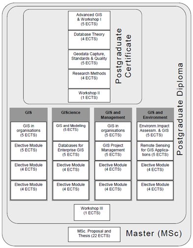
The Postgraduate Diploma in GIS is a modular study programme. Students will have to complete assignments of eight modules and attend at least two workshops at the Vrije Universiteit in Amsterdam.
In addition to the generalised GIS option, the student can choose from several specialised pathways: GIS, GIScience, GIS and Management, GIS and Environment.
The first four modules of the course are standard for all students, and give a solid foundation in the principles and issues of GIS. The remaining four modules can be selected (depending on the pathway chosen) from a growing list of optional modules, allowing each student
to follow a path to completion of the Diploma which best suits his/her particular study requirements. The programme can be completed in two years based on a schedule of studying approximately 10 hours per week.
|
The Postgraduate Certificate (PgC) - 19 ECTS
The Postgraduate Certificate in GIS is attained on completion
of the first four modules and a four-day workshop that is annually organized in June at the university. The programme can be
completed within one year.
The Postgraduate Diploma (PgD) - 38 ECTS
The Postgraduate Diploma in GIS is attained on completion
of the Postgraduate Certificate course plus another four modules and another four-day workshop at the university, again organized in June. The PgD programme can be
completed within two years.
Apply for the 1-year Certificate or 2-year Diploma Programme?
You can apply for the 1-year Certificate Programme or for the 2-year Diploma programme.
As the Certificate programme covers the same material as the first year of the Diploma Programme, you can continue with the second year of the Diploma Programme after you finish your Certificate Programme. So if you are not yet determined to do the Diploma Programme, you can just start with doing the Certificate Programme and then choose whether or not to continue with the Diploma Programme once you have finished the first year.
Please visit http://www.unigis.nl, download and fill in the Postgraduate Programme application form and tick either one of the options 'Postgraduate Certificate Programme' or 'Postgraduate Diploma Programme' on the first page.
On this form you can also indicate whether or not you have the intention to follow the complete Master programme. If you need a letter of acceptance into the Master programme because you are, for instance, looking for scolarships or other external funding for an accredited Master programme, please just fill this in at the appropriate question on the form, so that the Examination Committee can take this into account when reviewing your application.
Before you apply, be sure to check if you meet the entry requirements for direct admission into the programme. As our programme has a modular structure, the same entry requirements apply to all programmes: Postgraduate Certificate, Postgraduate Dilpoma and Master programme.
|