 GeoServices – 4 – Sustainability (GeoS4S)
Project No. 561716-EPP-1-2015-1-AT-EPPKA2-CBHE-JP
co-funded by the European Commission within ERASMUS+ Programme, 2015-18
INTRODUCTION
Ensuring social, economic and environmental sustainability is one major aim of all the countries but priorities are not the same world over. The partner countries, China and Thailand, are fast growing economies attracting a significant share of Foreign Direct Investment but facing a number of social and environmental challenges. Growing cities, expanding industry and increasing pollution of air, water and soil are big problems in both the countries which have several adverse effects on the society, environment and sustainable development.
Applications of Geospatial technologies and methodologies in socio‐economic analysis, natural resource management, economic planning, environmental management, sustainable development etc. have been well established during the last decades. However, Geospatial job‐market is largely controlled by International companies and these are in continuous pressure of delivering cost‐effective services and products. Although Geospatial education has been introduced at several HEIs in China and Thailand but the courses are largely taught in local language medium. Thailand is also a member of ASEAN Economic Community which is becoming a formal block of 10 countries in 2015. Due to these facts, both China and Thailand are making a number of efforts to internationalise their education systems which can be achieved faster by expanding international cooperation.
UNIGIS Amsterdam is a partner in the ERASMUS+ GeoServices-4-Sustainability project. The modules created and offered by the project are accessible (open/guest access) here. Further information is available at the project website.
OBJECTIVES
- Design the structure and syllabi of 20 innovative modules
- Develop case study based teaching / learning materials
- Give ‘hands-on’ practical training of delivering and working with the modules
- Launch an e-Learning platform for open and free access to the teaching / learning materials
- Initiate a framework for awarding ‘International Geospatial Qualification Certificate’ to those completing 30 ECTS courses from these modules.
ACTIVITIES
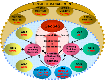
PARTNERS
Coordinating Institution
AUSTRIA: Interfaculty Department of Geoinformatics – Z_GIS, University of Salzburg, Salzburg
Partner Institutions
CZECH REPUBLIC: Palacky University, Ololouc
GERMANY: University of Sustainable Development, Eberswalde
NETHERLANDS: VU University, Amsterdam
CHINA:
– Nanjing Normal University, Nanjing
– Wuhan University, Wuhan
– Xinjiang Institute of Ecology and Geography – CAS, Urumqi
THAILAND:
– Asian Institute of Technology, Pathumthani
– Chiang Mai University, Chiang Mai
– King Mongkut’s University of Technology Thornburi
Associate Partners
NETHERLANDS:
– UNIGIS International Association
– Geospatial Media and Communications
THAILAND:
– GeoInformatics International
OUTCOMES
- Syllabi and Learning / Teaching Materials of 20 innovative modules jointly developed by the partners.
- 20 faculty members trained in designing and developing the learning / teaching materials of the 20 modules.
- 50 Faculty members and 150 students trained in working with and delivering learning / teaching materials of the newly developed 20 innovative modules.
- An e-Learning platform containing learning / teaching materials of the 20 innovative modules for open and free access worldwide.
- A framework for awarding an ‘International Geospatial Qualification Certificate’.
Contact at SPINlab: Bart Kusse or Niels van Manen