Skip to content
SPINlab Vrije Universiteit Amsterdam

SPINlab Vrije Universiteit Amsterdam

Spatial Information laboratory

Menu

  • Home
  • Research
    • Spatial Analysis & Modelling
      • Climate Adaptation
      • Spatial Planning
      • Land Use Modelling
      • Land Use Scanner model
      • Location value
    • GeoDesign
      • Wastecosmart
    • Risk Management
      • RWS 3D Linked Data Viewer
    • Spatial Digital Humanities
      • 3D GIS Via Appia
      • Archaeological Information System
      • EUWATHER
      • Rediscovering Testaccio
    • Sanne Hettinga
    • Jip Claassens
  • Education
    • UNIGIS Distance-learning MSc. in GIS
    • GeoServices 4 Sustainability
    • Supervised theses
  • Publications
    • Articles & book contributions
    • Conference & Seminar contributions a.o.
    • PhD dissertations
    • Reports
    • Research memoranda
    • Land Use Scanner publications
  • News & Agenda
  • About
    • Staff
    • Partners
      • PBL
      • RWS
    • Contact
  • Support
    • Spatial Data
    • GIS software
    • Tools & Models
      • Definite / BOSDA
      • GeoDMS BAG-Geocoder
      • Land Use Scanner – Student Edition
HERILAND - Cultural Heritage and the Planning of European Landscapes

HERILAND - Cultural Heritage and the Planning of European Landscapes

HERILAND is a pan-European research and training network on cultural heritage in relation to Spatial Planning and Design

Read more
VU campus

VU campus

Visit our campus in Amsterdam-Zuid

Read more
Geocoding using BAG-data

Geocoding using BAG-data

Download our free address geocoding tool

Read more
Urban Mobility Observatory

Urban Mobility Observatory

The Urban Mobility Observatory (UMO) is an extensive system of sensors and IT infrastructure to observe mobility and travel behavior.

Read more
Waterstaatskaart

Waterstaatskaart

A unique historical data source for the Dutch Water System

Read more

Digital twin Alkmaar

Als eerste stop op haar digitaliseringstour, deed de Staatssecretaris voor Koninkrijksrelaties en Digitalisering de gemeente Alkmaar aan. Tijdens dit werkbezoek werd de digital twin van Alkmaar officieel opengesteld. Als onderdeel van het inhoudelijk programma mocht de VU kort vertellen over recent mobiliteitsonderzoek

Jip Claassens 16th September 202221st September 2022 Uncategorised Read more

Floating car data reveals travel time reliability

Data obtained from in-car navigation software, traffic apps and fleet management software is a valuable new asset to describe mobility. Such floating car data holds great promise for a more detailed description of mobility patterns and a deeper understanding of

Jip Claassens 5th September 20225th September 2022 Uncategorised Read more

Spatial data science en mobiliteit

Mobiliteit is een van de drie grote maatschappelijke vraagstukken van dit moment. In het college/webinar van Data Science Alkmaar gisteren, gaven drie sprekers aan hoe we met ruimtelijke data & machine learning technieken diverse verkeersaspecten steeds beter in beeld krijgen.

Jip Claassens 24th June 202224th June 2022 Uncategorised Read more

PhD promotion Filipe Batista e Silva

On the 2nd of June 2022, Filipe Batista e Silva successfully defended his PhD dissertation at VU Amsterdam. The thesis, titled Geospatial data fusion for continental assessments of land use, activities and population distribution, proposes an advanced approach for fusing

Jip Claassens 2nd June 202224th June 2022 Uncategorised Read more

Webinar digital twins

Digital twin is het nieuwe buzzwoord in de wereld van data en AI. Maar: wat is het? Een digital twin is een virtuele representatie van een fysieke situatie of product. Het dynamisch meten vormt een belangrijk onderdeel van een DT

Jip Claassens 17th June 202124th June 2022 Uncategorised Read more

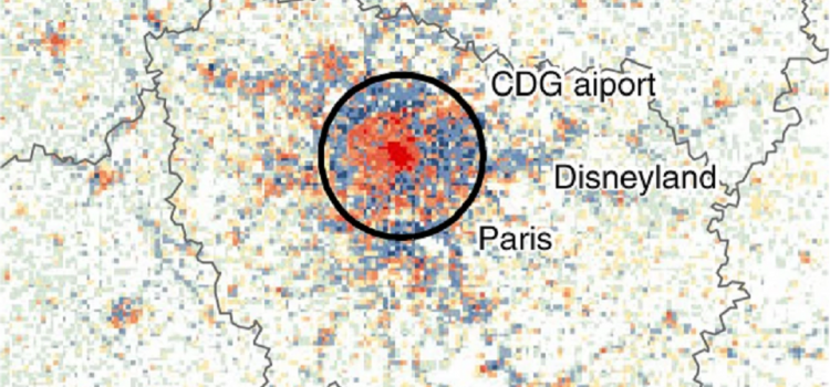
Europe’s population density patterns mapped in Nature Communications

Europe’s population density patterns mapped in Nature Communications

Filipe Batista e Silva is a PhD candidate at SPINlab working for the European Union’s Joint Research Centre. Over the past years he worked on uncovering temporal changes in Europe’s population density patterns using a data fusion approach. He combines

Dewi Westra 20th September 202020th September 2020 Research, Spatial analysis, Spatial Planning Read more

Theory and Application of Dynamic Spatial Time Series Models

Today Bo Andrée defended his PhD dissertation in an online session that had a live stream on YouTube. The somewhat impersonal, digital setting did not inhibit a lively discussion. Bo’s thesis sets out to develop theory and methods to analyze

Dewi Westra 26th May 202029th May 2020 News, PhD research Bo, Spatial analysis Read more

Relation between air pollution and confirmed COVID-19 cases researched

SPINlab doctoral candidate Bo Andree recently led a study on the relationship between air pollution and COVID-19 incidences in the Netherlands for The World Bank. With the spread of the virus several hotspots emerged around the globe, a number of which coincided

Dewi Westra 2nd May 20206th May 2020 Crisis Management, News, Research, Rural vitality, Uncategorised Read more

Voor een appartement wordt meer betaald

Dat kopte de NRC op 27 april over een onderzoek dat mede is uitgevoerd door SPINlab onderzoekers Jip Claassens en Bart Rijken. In dit onderzoek werd een vergelijking gemaakt tussen de bereidheid om te betalen voor binnenstedelijke appartementen en suburbane

Dewi Westra 27th April 20206th May 2020 Research, Spatial Planning, Sustainable Urban Development Read more

3D archeologie in Rome

Spinlab onderzoeker Maurice de Kleijn (geospatiaal archeoloog (PhD), en Rens de Hond (promovendus-archeoloog, 3D-specialist) hebben in de afgelopen maanden bijgedragen aan de tentoonstelling Via Appia Revisited. Tijdreizen over de Eeuwige Snelweg.  Deze tentoonstelling is een tijdreis langs de beroemde antieke

Dewi Westra 24th February 20206th May 2020 Digital Humanities, News, Uncategorised Read more
  • « Previous

Recent

  • Digital twin Alkmaar 16th September 2022
  • Floating car data reveals travel time reliability 5th September 2022
  • Spatial data science en mobiliteit 24th June 2022
  • PhD promotion Filipe Batista e Silva 2nd June 2022
  • Webinar digital twins 17th June 2021
  • Europe’s population density patterns mapped in Nature Communications 20th September 2020
  • Theory and Application of Dynamic Spatial Time Series Models 26th May 2020
  • Relation between air pollution and confirmed COVID-19 cases researched 2nd May 2020
  • Voor een appartement wordt meer betaald 27th April 2020
  • 3D archeologie in Rome 24th February 2020

Archive

Copyright © 2023 SPINlab Vrije Universiteit Amsterdam. All rights reserved. Theme Spacious by ThemeGrill. Powered by: WordPress.
  • Disclaimer
  • Cookie & Privacy Policy