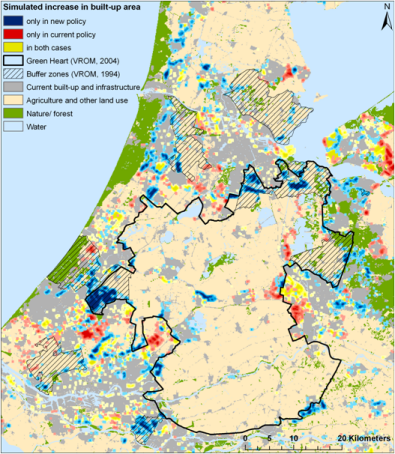
Spatial planning relates to policy interventions that aim to steer spatial developments in such a way that societal and environmental conditions are improving, whilst also meeting other objectives related to, for example, economic development, water management and biodiversity conservation. Reconciling these often conflicting objectives is an extremely demanding task that calls for: clear undisputed information on current developments; insight in possible future trends; the preparation of alternative policy measures and an understanding of their impact. Spatial analysis can provide the required information on past, current and projected spatial developments as well as indicate the impact of existing and proposed policy measures as is demonstrated in this thesis. See the figure on this page as an example of an analysis result (Source: Koomen and Dekkers, 2013).
SPINlab combines various forms of spatial analysis with newly available and highly detailed spatial data sets in research that supports the formulation of spatial polices in domains such as:
- open space preservation
- rural vitality
- urban intensification
- sustainable urban development
- attracting knowledge workers
Updates
Future land use mapped to assess upcoming water challenges

Water and spatial policy need to be better coordinated to prepare for upcoming climatic and societal changes. We are proud to have provided the land-use scenarios for this important policy advice presented by Deltares to the Minister of Infrastructure and Water Management. This study assesses the water challenges of...Read More »
Understanding the barriers for 15-minute cities
The new ENHANCE project aims to improve urban travel sustainability and equity by understanding current barriers for the application of 15-minute city (15mC) principles in outer metropolitan areas and small cities. Based on this understanding the project will propose strategies to overcome current obstacles in achieving more sustainable and equitable...Read More »
Twinning for climate-resilient urban solutions
University of Twente and Vrije Universiteit cooperated in a project to explore the potential of digital twins for developing sustainable, climate-resilient urban development strategies. Digital twins offer a realistic representation of the built environment based on a variety of spatial data sources. In combination with spatially explicit models that...Read More »
Europe’s population density patterns mapped in Nature Communications
Filipe Batista e Silva is a PhD candidate at SPINlab working for the European Union’s Joint Research Centre. Over the past years he worked on uncovering temporal changes in Europe’s population density patterns using a data fusion approach. He combines official statistics with geospatial data from emerging sources to produce...Read More »
Voor een appartement wordt meer betaald
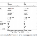
Dat kopte de NRC op 27 april over een onderzoek dat mede is uitgevoerd door SPINlab onderzoekers Jip Claassens en Bart Rijken. In dit onderzoek werd een vergelijking gemaakt tussen de bereidheid om te betalen voor binnenstedelijke appartementen en suburbane (eengezins)woningen. Door de kenmerken van 2,6 miljoen verkochte woningen in...Read More »