The SPINlab is the contact point for the campus’ IT-services where it concerns testing and installation of GIS software packages on the university campus. Also, we manage software licenses for students and university employees who want to install GIS software at home and can offer (limited) support when people experience software issues. Further, we manage the ArcGIS Online platform for the Vrije Universiteit, including licenses for ArcGIS Pro.
Currently, the following GIS software is available on VU campus computers (Windows OS):
- ArcGIS Desktop 10.4.1
- Quantum GIS (QGIS) 2.14.10 LTR – also for Mac
- Geo Data and Model Server (GeoDMS)
- ArcGIS Pro (64-bit)
- ERDAS
- ArcGIS Desktop, including extensions. Since September 2016, the current version that runs on the campus computers is version 10.4.1.
 Additionally, the following extensions are installed on the campus computers:
- ArcGIS Data Interoperability extension
(for importing and exporting a range of data formats) - ArcGIS VBA Compatibility extension
- ArcGIS Data Reviewer for Desktop
(for checking your data quality) - ArcGIS Coordinate Systems Data for Windows
(contains a range of vertical conversion algorithms, which is convenient if you want to work with X,Y,Z-data)
- ArcGIS Data Interoperability extension
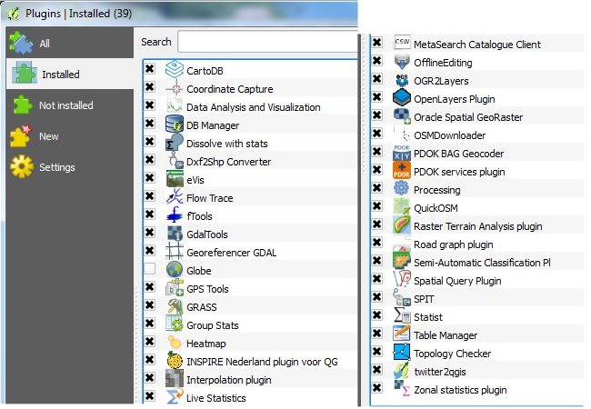
- Quantum GIS (QGIS). Since February 2017, we have installed Long Term stable Release version 2.14.10
 on the campus computers. Since QGIS itself contains only basic functionality, certainly compared to ArcGIS Desktop, we have included a pre-installed list of additional plugins on the campus computers and further advise you to include at least the following plugins:
- The Geo Data and Model Server (GeoDMS) is an open source GIS platform. We use it primarily for running
 the Land Use Scanner model during educational exercises and research projects where we make maps belonging to scenarios of the future of the Netherlands.
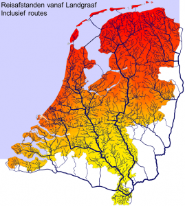
The GeoDMS focuses on the raster data model, but also has some (limited) vector GIS functionality incorporated. The software can process large amounts of raster data very rapidly.At the moment, we run version 6.054 at the campus computers. A newer version of this tool (version 7.026 or higher) can be used for geocoding Dutch data sets using the Basic administration of Adresses and Buildings (BAG in Dutch) as a geocoding-source. We have co-developed this tool with Object Vision B.V., the company repsonsible for maintenance and further development of the GeoDMS software.See the tool section of this website for more information about this specific application, and visit the Web Gallery of Object Vision for an overview of a range of other applications in which the GeoDMS software has been used, including, for instance, accessibility analysis as depicted in the image to the right.
For VU employees and students, all of the aforementioned software packages are also available to install on your personal computer or laptop. Quantum GIS has the advantage that it also can be installed on Mac OS platforms, in contrast to ArcGIS Desktop which is only available for Windows machines.
But there is more:
 ArcGIS Pro is a software package that you can install locally. It has an increasing amount of functionality and has another look and feel than ArcGIS Desktop (compare the old Office-look versus the new look with ribbon interface on top). For beginning GIS-professionals and -students, ArcGIS Pro is perceived as being more easy to learn than ArcGIS Desktop.In order for it to run, you need to have an ArcGIS Online account and be a member of the Vrije Universiteit ArcGIS Online group. SPINLab can arrange that for you if you are a VU-employee or -student.
Note: ArcGIS Pro only runs on 64-bit computers. In the student computer rooms, these will only be available from 2017 onwards. For use at home, you can download ArcGIS Pro from http://download.vu.nl.
With ArcGIS Desktop and, more directly, with ArcGIS Pro it is easy to publish and share spatial data and maps on the ArcGIS Online platform.
- Furthermore, students of the National GI minor can use the ERDAS Imagine 2016 software,
 offered to you by Hexagon Geospatial, one of the largest GIS software companies worldwide.
The students can use this specialized software to explore the principles of data pre-processing and the basics of remote sensing and satellite imagery c.q. (ortho-)photo processing.