Geodesign tools can be used to support collaborative processes. Typical tools combine different methods, such as simulation models, spatial multi-criteria analysis, visualization, and optimization.
User-friendly interfaces allow multiple users to provide input and generate real-time output to support negotiated spatial decisions. Geodesign can be defined as follows: “Geodesign is a design and planning method which tightly couples the creation of design proposals with impact simulations informed by geographic contexts, systems thinking and digital technology “(Steinitz 2012, p.12).
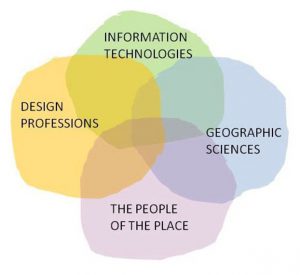
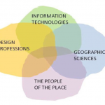
Geodesign combines the knowledge of local stakeholders (the people of the place) with contributions design professionals, Information technology and geographic sciences.
Some examples (in dutch) can be found here. Another nice and simple example of geodesign is shown in the movie below.
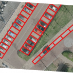
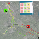
The task is to locate recycling containers in part of Amsterdam in such a way that the walking distances to these containers are minimized. The colours indicate the distance to the nearest container. The movie shows how the local expert finds the best location for five containers by moving these containers around on a touch screen.
In our view this is geodesign at its best:
- The tool is based on spatial information;
- The tool is interactive;
- The tool produces a spatial design
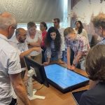
In a recent project we applied our experience with geodesign in data rich environments such as the Netherlands and the UK to design an approach for interactive workshops in the Lower Zambezi valley, Mozambique. Instead of a model based application that provides real time response to proposed changes, we designed a tool that facilitated open discussion and relied heavily on visualization. This approach required no calculation steps (the local stakeholders provided the input) and relied heavily on drawing and icons. This appealed to the participants and the absence of a quantitative model was not seen as a problem. Despite the simple strategy, the tool served its purpose well. It was interesting to observe that we were able to use the principles of our more sophisticated tools in an approach that was simpler, but also much more graphical in order to promote discussion and understanding.
Updates
Twinning for climate-resilient urban solutions
University of Twente and Vrije Universiteit cooperated in a project to explore the potential of digital twins for developing sustainable, climate-resilient urban development strategies. Digital twins offer a realistic representation of the built environment based on a variety of spatial data sources. In combination with spatially explicit models that...Read More »
Digital twin Alkmaar
Als eerste stop op haar digitaliseringstour, deed de Staatssecretaris voor Koninkrijksrelaties en Digitalisering de gemeente Alkmaar aan. Tijdens dit werkbezoek werd de digital twin van Alkmaar officieel opengesteld. Als onderdeel van het inhoudelijk programma mocht de VU kort vertellen over recent mobiliteitsonderzoek waarin op basis van luchtfoto’s en gedetailleerde satellietbeelden geparkeerde...Read More »
Webinar digital twins
Digital twin is het nieuwe buzzwoord in de wereld van data en AI. Maar: wat is het? Een digital twin is een virtuele representatie van een fysieke situatie of product. Het dynamisch meten vormt een belangrijk onderdeel van een DT en dus is integratie met de wereld van sensoren (Internet of...Read More »
Inzet Geodesign voor Ruimtelijke Prioritering van onderhoud aan (vaar)wegen
Op verzoek van Rijkswaterstaat Oost Nederland is in maart dit jaar gestart met het project Geodesign voor Ruimtelijke Prioritering van Onderhoud aan Wegen en Vaarwegen. In dit project wordt nagegaan of geodesign een zinvolle bijdrage kan leveren aan de ruimtelijke prioritering van het onderhoud van sluizen, bruggen en (vaar)wegen. In...Read More »
Strategische Verkenning Geodesign
Een extra dimensie voor ruimtelijke informatie met geodesign
De hoeveelheid aanwezige data bij Rijkswaterstaat (RWS) is enorm. Het is belangrijk om deze informatie zodanig te ontsluiten dat er binnen de planvorming optimaal gebruik van kan worden gemaakt. Een goede kaartafbeelding is een belangrijke eerste stap voor het gebruik van ruimtelijke informatie...Read More »