Geodesign tools can be used to support collaborative processes. Typical tools combine different methods, such as simulation models, spatial multi-criteria analysis, visualization, and optimization.
User-friendly interfaces allow multiple users to provide input and generate real-time output to support negotiated spatial decisions. Geodesign can be defined as follows: “Geodesign is a design and planning method which tightly couples the creation of design proposals with impact simulations informed by geographic contexts, systems thinking and digital technology “(Steinitz 2012, p.12).
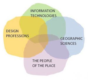
Geodesign combines the knowledge of local stakeholders (the people of the place) with contributions design professionals, Information technology and geographic sciences.
Some examples (in dutch) can be found here. Another nice and simple example of geodesign is shown in the movie below.
The task is to locate recycling containers in part of Amsterdam in such a way that the walking distances to these containers are minimized. The colours indicate the distance to the nearest container. The movie shows how the local expert finds the best location for five containers by moving these containers around on a touch screen.
In our view this is geodesign at its best:
- The tool is based on spatial information;
- The tool is interactive;
- The tool produces a spatial design
In a recent project we applied our experience with geodesign in data rich environments such as the Netherlands and the UK to design an approach for interactive workshops in the Lower Zambezi valley, Mozambique. Instead of a model based application that provides real time response to proposed changes, we designed a tool that facilitated open discussion and relied heavily on visualization. This approach required no calculation steps (the local stakeholders provided the input) and relied heavily on drawing and icons. This appealed to the participants and the absence of a quantitative model was not seen as a problem. Despite the simple strategy, the tool served its purpose well. It was interesting to observe that we were able to use the principles of our more sophisticated tools in an approach that was simpler, but also much more graphical in order to promote discussion and understanding.
Updates
Minecraft planning op Zeeburgereiland
Zeeburgereiland (Amsterdam) is volop in ontwikkeling. De eerste bewoners zijn reeds gearriveerd. De eerste tijdelijke initiatieven krijgen langzaam maar zeker vorm. De bewoners van Nautilus denken na over een buurtpark, een drietal bewoners hebben zich verenigd en bouwen aan een moestuin. Ook voor de jongere bewoners van het eiland is...Read More »
Project Mozambique
Project Mozambique: A pictorial approach to geodesign: a case study for the Lower Zambezi valley
In a recent project the SPINlab Geodesign team has applied it’s experience with geodesign in data rich environments such as the Netherlands and the UK to design an approach for interactive workshops in the Lower Zambezi...Read More »
Springer book on GeoDesign published
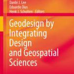
Springer published the book by Spinlab researchers Danbi Lee, Eduardo Dias and Henk Scholten about Geodesign examples and success stories:
Lee, D.J., Dias, E.S. & Scholten, H.J. (eds), Geodesign by Integrating Design and Geospatial Sciences, GeoJournal Library Series, Volume 111, Springer, 2014
The book, a.o. contains:
- Carl Steinitz’s introduction to his seminal...Read More »
UNIGIS Annual Alumni Day 2014

This year’s Alumni Day Theme is: 3D/4D/5D GIS: on the brink of a Revolution? The challenges and opportunities for data management, modelling and geodesign
We invite you to join us at the Annual Alumni Day. We will invite speakers from in- and outisde our university for interesting lectures. We hope...Read More »