An example of the use of Geographical Information Science & Systems in the fields of history & heritage is explained by Maurice de Kleijn in the next video:
Nacht van Rome
Op zaterdag 26 mei spreekt dr. Maurice de Kleijn tijdens de Nacht van Rome in de Balie Amsterdam. Hij demonstreert hoe moderne archeologen en architectuurhistorici digitale 3D technologie gebruiken om het verleden te simuleren. Hij neemt u daarvoor mee naar de eerste mijlen van de Via Appia. Meer info: http://www.nachtvanrome.nl/...Read More »Promotie virtueel tijdreizen. Digitale ruimtelijke technieken om het verleden te onderzoeken
VIRTUEEL TIJDREIZEN. DIGITALE RUIMTELIJKE TECHNIEKEN OM HET VERLEDEN TE ONDERZOEKEN
19-01-2018
Tijd: 13.45
Aula
Innovating Landscape Research through Geographic Information Science
M.T.M. de Kleijn
The Waterstaatskaart, a unique historical data source for the Dutch Water System
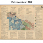
Researchers from the Spatial Information Laboratory (SPINlab) are currently working on a project to explore the possibilities of the Waterstaatskaart, a 19th century map containing all kind of information on the Dutch water system on a national scale. By analysing this historical map and translating the information into digital GIS...Read More »
3D Archeologie bij de Universiteit van Nederland
Towards the (Dutch) Archaeological Linked Open Data Cloud
Spinlab researcher Xander Wilcke is working on a solution to release archaeological knowledge that is now often stored on hard drives and only accessible by request.
The Archaeological Protocol 0102 provides a specification as to how rich XML summarizations, aptly named the pakbon (package slip in English), could and...Read More »