 Building an SDI for scientific research of the history and heritage of the Dutch landscape
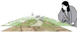
Rediscovering Landscape addresses the need for accessible information to support the research of the history and heritage of the Dutch landscape. It develops a Spatial Data Infrastructure (SDI) for exploring the increasing amount of digital data in this research field, and for cross-cutting the boundaries between disciplines, periods and regions.
For more information, visit the project website at www.rediscoveringlandscape.nl or read the Project Description below.
Project Description
Rediscovering Landscape addresses the need for reliable and accessible information to support the scientific research of the history and heritage of the Dutch landscape. The programme aims at building a Spatial Data Infrastructure (SDI), as well as implementing organisational measures for sustaining the infrastructure in the long-term, on a national basis, and in line with international standards and initiatives. The SDI will function as a coherent system of digital data and information, agreements, standards, technology (hardware, software and electronic communication) and knowledge, providing the different users with information needed to carry out scientific landscape research.
The urgency of building such an infrastructure is widely recognised, not only by Dutch experts in the field (Scholten et al. [eds] 2009; Bloemers et al. [eds] 2010; Vervloet 2011), but also in international (science) policy frameworks, such as the Malta Convention (1992), the European Landscape Convention (2000), and the INSPIRE directives regarding the interoperability of spatial data sets and services (2011). Its specific importance for the Dutch research community is illustrated by the large number of universities, libraries and centres of expertise that are committed to participating in the proposed programme (see below). The SDI is necessary for better exploring, exchanging and combining the increasing amount of digital data and information about the history and heritage of the Dutch landscape, and for making new connections and comparisons by cross-cutting existing boundaries between different disciplines, time periods and geographical areas. In this way, the infrastructure will pave the way for a true scientific “rediscovery” of past landscapes and present-day “heritagescapes” that now remain hidden in a wealth of digital data and information produced in more than thirty years of landscape and heritage research.
The SDI is crucial for maintaining the high academic standard of the Dutch research in this field and is of vital importance for continuing to act at the forefront of international landscape and heritage research. Additionally, the SDI will facilitate a more effective application of scientific knowledge to the preservation and sustainable management of valuable landscapes and heritage sites in the Netherlands.
Rediscovering Landscape is an initiative of six Dutch universities (VU University Amsterdam, Wageningen University & Research centre, University of Groningen, University of Leiden, Delft University of Technology and University of Utrecht), several university libraries, Data Archiving and Networked Services (DANS), the National Heritage Agency (RCE), and several non-governmental (commercial) organisations. Together, they make up a consortium with extensive experience conducting landscape and heritage research as well as applying scientific insights into heritage management, landscape design and spatial planning. The challenge of building the SDI – as a successful national facility and infrastructure – exceeds the financial and organisational capacity of the individual partners. It demands their collective effort with the support of NWO.
The proposed programme builds upon an NWO pilot project (file: 380-57-001) that was conducted by the partners in 2010 and is concluded with this proposal.
Publications related to Rediscovering landscape
| de Hond, R., Mapping the Via Appia – 3d GIS, Presentation for the Mini Conference 3D GIS for Mapping the Via Appia, VU University Amsterdam, 2013. | |
| UMAP 2013 | de Kleijn, M.T.M., van Aart, C., van Manen, N., Burgers, G-J., Scholten, H.J., Testaccio, A Digital Cultural Biography App, in: UMAP 2013 Extended Proceedings of the 21st Conference on User Modeling, Adaptation, and Personalization, Rome, Italy, June 10-14, 2013. |
| Piccoli, C., CityEngine for Archaeology, Presentation for the Mini Conference 3D GIS for Mapping the Via Appia, VU University Amsterdam, 2013. |