Skip to content
SPINlab Vrije Universiteit Amsterdam

SPINlab Vrije Universiteit Amsterdam

Spatial Information laboratory

Menu

  • Home
  • Research
    • Accessibility
    • Spatial Analysis & Modelling
      • Land Use Modelling
        • Land Use Scanner model
        • Land Use Scanner – Student Edition
      • Climate Adaptation
      • Spatial Planning
      • Location value
    • GeoDesign
      • Wastecosmart
    • Tools & Models
      • Definite / BOSDA
      • GeoDMS BAG-Geocoder
    • Research archive
      • Risk Management
        • RWS 3D Linked Data Viewer
        • GDI4DM
      • Spatial Digital Humanities
        • 3D GIS Via Appia
        • Archaeological Information System
        • CLUE
        • EUWATHER
        • Rediscovering Testaccio
        • Rediscovering landscape
        • citivu.nl
      • GeoServices 4 Sustainability
  • Education
    • UNIGIS Distance-learning MSc. in GIS
    • Supervised theses
  • Support
  • Publications
    • ISAAC
    • PhD dissertations
    • Land Use Scanner publications
  • News & Agenda
  • About
    • Staff
    • Partners
      • PBL
      • RWS
    • Contact

Land Use Scanner

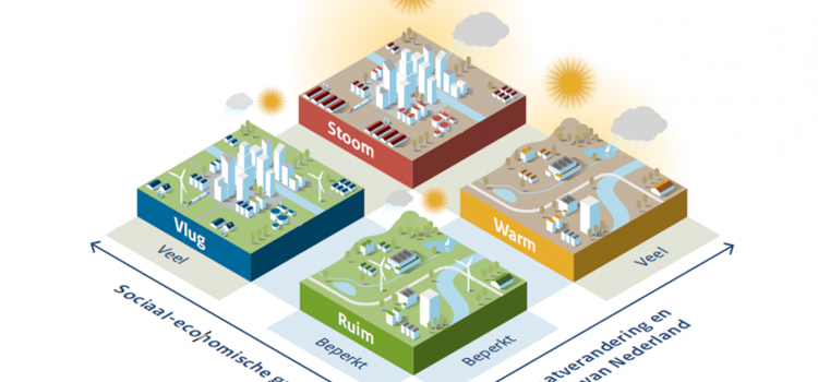
Future land use mapped to assess upcoming water challenges
Future land use mapped to assess upcoming water challenges

Water and spatial policy need to be better coordinated to prepare for upcoming climatic and societal changes. We are proud to have provided the land-use scenarios for this important policy advice presented by Deltares to the Minister of Infrastructure and

Eric Koomen 24th April 202415th May 2024 Land Use Scanner, Land-Use Modelling, Spatial Planning, Uncategorised Read more

Where to build our houses?

Stel nu dat we bodem en water echt serieus nemen bij de inrichting van Nederland zoals de overheid beoogt? Voor Follow the Money heeft het SPINlab gekeken wat geschikte plekken voor woningbouw zijn. Een paar simpele uitgangspunten staan daarbij centraal:

Jip Claassens 18th April 202326th June 2023 Land Use Scanner, Land-Use Modelling, Research, Spatial analysis and modelling Read more

Knowledge for climate – Theme 8: Socio-economic scenarios updated

The updated land-use projections related to the Global Economy (GE) and Regional Communities (RC) scenarios have been released. These scenarios were initially developed by a consortium of Dutch research institutes (CPB et al., 2006) and translated into land-use projections in

Maurice de Kleijn 1st March 20138th November 2018 Land Use Scanner, Land-Use Modelling No Comments Read more

Latest updates

  • Vulnerable areas prone to urban development 1st July 2024
  • Future land use mapped to assess upcoming water challenges 24th April 2024
  • Understanding the barriers for 15-minute cities 18th October 2023
  • Twinning for climate-resilient urban solutions 12th June 2023
  • Where to build our houses? 18th April 2023
Copyright © 2025 SPINlab Vrije Universiteit Amsterdam. All rights reserved. Theme Spacious by ThemeGrill. Powered by: WordPress.
  • Disclaimer
  • Cookie & Privacy Policy