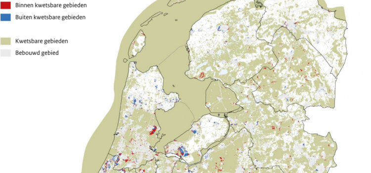
Around 40% of future urban development in the Netherlands is likely to take place within vulnerable areas. The development of new houses, industrial estates and holiday homes until 2050 may affect large areas with natural, landscape or cultural values. The
PhD defense Filipe Batista e Silva
On the 2nd of June 2022, Filipe Batista e Silva successfully defended his PhD dissertation at VU Amsterdam. The thesis, titled Geospatial data fusion for continental assessments of land use, activities and population distribution, proposes an advanced approach for fusing
Theory and Application of Dynamic Spatial Time Series Models
Today Bo Andrée defended his PhD dissertation in an online session that had a live stream on YouTube. The somewhat impersonal, digital setting did not inhibit a lively discussion. Bo’s thesis sets out to develop theory and methods to analyze
PhD promotion Ting Zou
Last January Ting Zou successfully defended her PhD dissertation at the VU University. Her thesis Landscape service provisions and preferences on the urban–rural fringe ‘attempts to investigate changes in landscape service supply and people’s preferences towards these services over space
Urban densification session at RSA conference
VU-SPINlab organized a special session on urban densification at the Regional Studies Association’s winter conference in London last week. The central question was: Are cities dense enough? Several speakers from universities and the European Commission addressed this question, explaining regional
Famine Action Mechanism
PhD candidate Bo Andrée is working on an ambitious high profile project at the World Bank: the Famine Action Mechanism (FAM). This project seeks to monitor and detect early signs of famine risk and link forecasts to prearranged and agreed
Vasco Diogo defends his PhD
On October 12, Vasco Diogo has successfully defended his PhD dissertation at the VU University. His thesis ‘Agricultural land systems: Explaining and simulating agricultural land-use patterns’ reveals to what extent empirical and theory-based approaches of spatial analysis and land-use modelling
3D Archeologie bij de Universiteit van Nederland
In een unieke samenwerking tussen archeologen, geodeten en informatici is een onderzoeksinstrument ontwikkeld dat de archeologen in staat stelt hun onderzoeksgebied – een deel van de vijfde en de zesde mijl vanaf het centrum van Rome – in een virtuele
Ruimtelijke analyses relatie stedelijk landgebruik, lokale kenmerken en lange-afstandsbereikbaarheid
Promotie SPINlab-onderzoeker Chris Jacobs-Crisioni 30 november 2016, Vrije Universiteit Amsterdam De verhitte concurrentie tussen spoorexploitanten heeft gezorgd voor overinvestering op het netwerk en bijgedragen aan een te dicht spoornetwerk in Nederland. Het 19e-eeuwse Nederlandse spoorwegnetwerk is voornamelijk ontwikkeld voor winst
Chris Jacobs-Crisioni contributes to Dutch TV-show about the invisible past
SPINlab PhD candidate Chris Jacobs-Crisioni recently contributed some of his research data to a Dutch TV-show, ‘Onzichtbaar Nederland’ (‘The invisible Netherlands’). That show takes the viewer through physical and societal changes in the country with often spectacular GIS visualizations. The