Skip to content
SPINlab Vrije Universiteit Amsterdam

SPINlab Vrije Universiteit Amsterdam

Spatial Information laboratory

Menu

  • Home
  • Research
    • Accessibility
    • Spatial Analysis & Modelling
      • Land Use Modelling
        • Land Use Scanner model
        • Land Use Scanner – Student Edition
      • Climate Adaptation
      • Spatial Planning
      • Location value
    • GeoDesign
      • Wastecosmart
    • Tools & Models
      • Definite / BOSDA
      • GeoDMS BAG-Geocoder
    • Research archive
      • Risk Management
        • RWS 3D Linked Data Viewer
        • GDI4DM
      • Spatial Digital Humanities
        • 3D GIS Via Appia
        • Archaeological Information System
        • CLUE
        • EUWATHER
        • Rediscovering Testaccio
        • Rediscovering landscape
        • citivu.nl
      • GeoServices 4 Sustainability
  • Education
    • UNIGIS Distance-learning MSc in GIS
    • Supervised theses
  • Publications
    • PhD dissertations
    • Land Use Scanner publications
  • News & Agenda
  • About
    • Staff
    • Contact

News

Vulnerable areas prone to urban development
Vulnerable areas prone to urban development

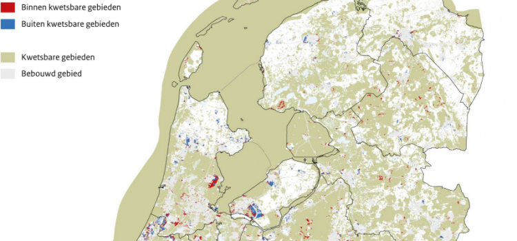
Around 40% of future urban development in the Netherlands is likely to take place within vulnerable areas. The development of new houses, industrial estates and holiday homes until 2050 may affect large areas with natural, landscape or cultural values. The

Eric Koomen 1st July 20241st August 2024 Land-Use Modelling, News, PhD research Jip, Research, Spatial Planning, Sustainable Urban Development Read more

PhD defense Filipe Batista e Silva

On the 2nd of June 2022, Filipe Batista e Silva successfully defended his PhD dissertation at VU Amsterdam. The thesis, titled Geospatial data fusion for continental assessments of land use, activities and population distribution, proposes an advanced approach for fusing

Jip Claassens 2nd June 202226th June 2023 Land-Use Modelling, News, PhD Research, Research, Seminars Read more

Webinar digital twins

Digital twin is het nieuwe buzzwoord in de wereld van data en AI. Maar: wat is het? Een digital twin is een virtuele representatie van een fysieke situatie of product. Het dynamisch meten vormt een belangrijk onderdeel van een DT

Jip Claassens 17th June 202126th June 2023 Geodesign, News, Research, Seminars Read more

Theory and Application of Dynamic Spatial Time Series Models

Today Bo Andrée defended his PhD dissertation in an online session that had a live stream on YouTube. The somewhat impersonal, digital setting did not inhibit a lively discussion. Bo’s thesis sets out to develop theory and methods to analyze

Eric Koomen 26th May 202029th May 2020 News, PhD research Bo, Spatial analysis Read more

Relation between air pollution and confirmed COVID-19 cases researched

SPINlab doctoral candidate Bo Andree recently led a study on the relationship between air pollution and COVID-19 incidences in the Netherlands for The World Bank. With the spread of the virus several hotspots emerged around the globe, a number of which coincided

Eric Koomen 2nd May 202026th June 2023 Crisis Management, News, Research, Rural vitality Read more

3D archeologie in Rome

Spinlab onderzoeker Maurice de Kleijn (geospatiaal archeoloog (PhD), en Rens de Hond (promovendus-archeoloog, 3D-specialist) hebben in de afgelopen maanden bijgedragen aan de tentoonstelling Via Appia Revisited. Tijdreizen over de Eeuwige Snelweg.  Deze tentoonstelling is een tijdreis langs de beroemde antieke

Eric Koomen 24th February 202026th June 2023 Digital Humanities, News Read more

PhD promotion Ting Zou

Last January Ting Zou successfully defended her PhD dissertation at the VU University. Her thesis Landscape service provisions and preferences on the urban–rural fringe ‘attempts to investigate changes in landscape service supply and people’s preferences towards these services over space

Eric Koomen 22nd January 202015th June 2022 News, PhD Research, Spatial Planning Read more

Vasco Diogo defends his PhD

On October 12, Vasco Diogo has successfully defended his PhD dissertation at the VU University. His thesis ‘Agricultural land systems: Explaining and simulating agricultural land-use patterns’ reveals to what extent empirical and theory-based approaches of spatial analysis and land-use modelling

Paolo Tasseron 12th October 20188th November 2018 Land-Use Modelling, News, PhD Research Read more

Large Grant to set up Urban Mobility Observatory

NWO has awarded seven proposals for innovative research infrastructure within the programme NWO Investment Grant Large. With this programme, NWO funds large research facilities, within which researchers from throughout the Netherlands work together, often with international partners. Erik Verhoef, together

Paolo Tasseron 27th September 201812th November 2018 News, Research Read more

Stem op GeoFort!

GeoFort is in de race voor de Museumprijs 2018!   Al jaren werken we als Spinlab VU samen met GeoFort. Zo hebben we samen heel Nederland in minecraft omgezet en een geweldig educatief platform gecreëerd waarin kinderen, docenten en jongeren

Maurice de Kleijn 20th April 201826th June 2023 News Read more
  • « Previous

Latest updates

  • Vulnerable areas prone to urban development 1st July 2024
  • Future land use mapped to assess upcoming water challenges 24th April 2024
  • Understanding the barriers for 15-minute cities 18th October 2023
  • Twinning for climate-resilient urban solutions 12th June 2023
  • Where to build our houses? 18th April 2023

Recent Posts

  • Vulnerable areas prone to urban development
  • Future land use mapped to assess upcoming water challenges
  • Understanding the barriers for 15-minute cities
  • Twinning for climate-resilient urban solutions
  • Where to build our houses?

Recent Comments

    Archives

    • July 2024
    • April 2024
    • October 2023
    • June 2023
    • April 2023
    • September 2022
    • June 2022
    • June 2021
    • September 2020
    • May 2020
    • April 2020
    • February 2020
    • January 2020
    • November 2019
    • June 2019
    • December 2018
    • November 2018
    • October 2018
    • September 2018
    • August 2018
    • June 2018
    • May 2018
    • April 2018
    • March 2018
    • January 2018
    • September 2017
    • July 2017
    • May 2017
    • March 2017
    • January 2017
    • December 2016
    • November 2016
    • October 2016
    • September 2016
    • June 2016
    • April 2016
    • February 2016
    • January 2016
    • December 2015
    • November 2015
    • October 2015
    • July 2015
    • June 2015
    • May 2015
    • March 2015
    • February 2015
    • January 2015
    • December 2014
    • November 2014
    • June 2014
    • March 2014
    • February 2014
    • January 2014
    • December 2013
    • November 2013
    • October 2013
    • September 2013
    • June 2013
    • March 2013
    • October 2012
    • September 2012
    • November 2011
    • August 2010
    • September 2009
    • July 2009
    • September 2008

    Latest News

    • Accessibility
    • Chris Jacobs-Crisioni
    • Climate change
    • Crisis Management
    • Digital Humanities
    • Education
    • EduGIS
    • Geodesign
    • Land Use Scanner
    • Land-Use Modelling
    • Maurice de Kleijn
    • News
    • PhD Research
    • PhD research Bo
    • PhD research Jip
    • Research
    • Rijkswaterstaat
    • Rural vitality
    • Seminars
    • Spatial analysis
    • Spatial analysis and modelling
    • Spatial Planning
    • Support
    • Sustainable Urban Development
    • Uncategorised
    • UNIGIS

    Meta

    • Log in
    • Entries feed
    • Comments feed
    • WordPress.org
    Copyright © 2025 SPINlab Vrije Universiteit Amsterdam. All rights reserved. Theme Spacious by ThemeGrill. Powered by: WordPress.
    • Disclaimer
    • Cookie & Privacy Policy